|
Leer en Español Which Part Of The Geography Of Chile Do You Like?
I’m going to tell you the highlights of the geography of Chile.... so you can use it to your benefit in deciding which part of Chile you think would suit you best. Let's start with some general information about the geography of Chile.
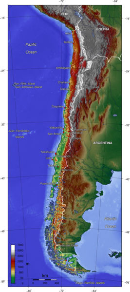
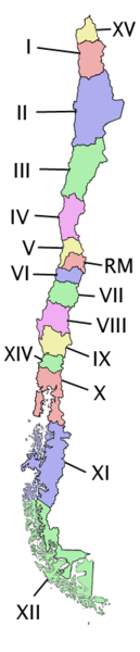
Chile starts up in the north at 17° latitude, south of the equator.On the northern border its neighbors with Peru and on the north-east border with Bolivia. The rest of the eastern border is with Argentina.The western part of Chile is bordering the South Pacific Ocean from tip to tip So it has a very long coast. Continental Chile is 4,270 kms long from north to south. It has an average of 177 kms from east to west and its thinnest point is in Illapel with 80 kms wide aprox. Chile’s a very long and thin country that curves eastward at the southern point (Cape Horn). This is the only part that has a bit of Atlantic Ocean. The Andes mountains, that start in Venezuela, crosses through Chile making about 80 % of the geography of Chile mountains and volcanoes. Chile has about 620 volcanoes of its own. There´s also a portion of non- Andean mountains that usually, (but not always), appear and form part of the transverse and coastal ranges. This is seen mostly in the northern territories where it extends from the Andes to the ocean creating valleys in an east-western direction. The best example ofthis is the Central Valley. In most of the country there are four seasons: The climate in Chile varies on two factors; the first factor is the latitude,(like everywhere else), and the other is the location. By this I mean if the territory is located in the eastern, western or the central portion of the country. The northern part of Chile has warm climate and the southern part of Chile is colder. But if you take one portion of the country,like the eastern part, it will have temperatures of high altitude,the central part will have very extreme temperatures and the coast portion has temperatures that don’t vary much. But for geographic purposes, and because their climates are alike, they divide up the continental country in 3 groups. There’s also: Return from Geography of Chile page to Chile Tourism home
|