Regional Chile Maps
These Chile maps are divided into individual maps of each region of Chile. From the 1st region down to the 12th region. These maps are divided with the older version of the regions in Chile. They where recently changed in the year 2007 adding two more regions, but I will mention what region is changed when you look at the specific region involved. If you are looking for more general maps click here!
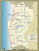
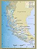
These maps are very basic maps of each region naming their main cities and their main routes. The red lines are the Panamerican Highway and the yellow and pink lines show the smaller roads.
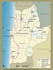
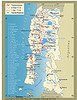
Map of 15th and 1st regions
 This is a map of the 15th Region (Arica y Parinacota) and the 1st Region (Tarapaca). This is one of those regions recently changed. The 15th region starts at the limit with Peru and ends in the area where it says Camarones. Below this area starts the 1st region.
Click Here
to see map.
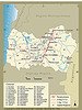
Map of 2nd region
This map is of the 2nd Region (Antofagasta)
Click Here
to see in large
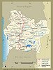
Map of 3rd Region
This map is of the 3rd Region (Atacama)
Click Here
to see in large
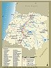
Map of 4th Region
This map is of 4th Region (Coquimbo)
Click Here
to see in large
Map of 5th Region
This map is of 5th Region (Valpariso)
Click Here
to see in large
Map of 6th Region
This map is of 6th Region (Libertador Bernardo O’higgins)
Click Here
to see in large
Map of 7th Region
This map is of 7th Region (Maule)
Click Here
to see in large
Map of 8th Region
This map is of 8th Region (Bio Bio)
Click Here
to see in large
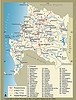
Map of 9th Region
This map is of 9th Region (Araucania)
Click Here
to see in large
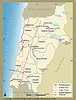
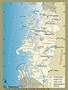
Map of 14th and 10th Region
 This map is of 14th Region (Los Rios) and the 10th Region (Los Lagos). This is the other region recently changed. The 14th starts at the limit with the 9th region and it ends with the area called La Unión, on the map you can see a river (Rio Bueno) just below that area, this is the limit with the 10th region.
Click Here
to see in large
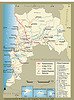
Map of 11th Region
 This map is of 11th Region (Aysen Del General Carlos Ibañez Del Campo)
Click Here
to see in large
Map of 12th Region
This map is of 12th Region (Magallenes y Antartica Chilena)
Click Here
to see in large
Map of 13th Region
I’m sorry but I couldn’t find the map of 13th Region (RM) Metropolitana
Return from Regional Chile Maps to Chile Maps